By Johnathan Paoli
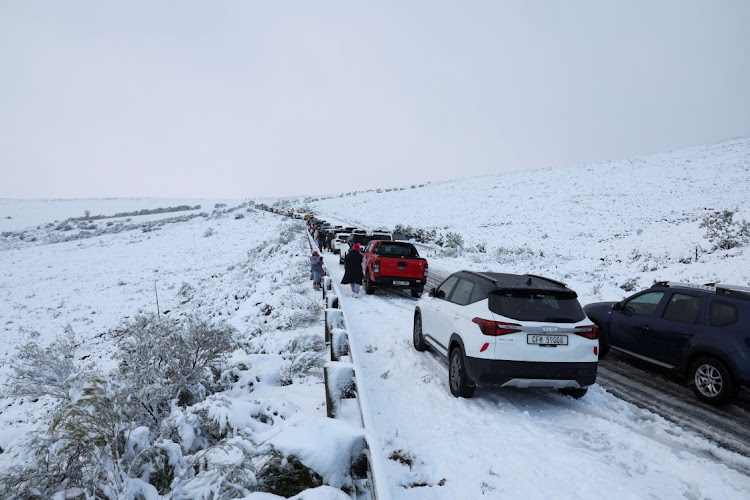
South Africa is facing one of the most severe cold snaps in recent years as two powerful cold fronts move across the country, bringing plunging temperatures, heavy rainfall, snow, and damaging winds.
The South African Weather Service (SAWS) issued multiple warnings on Tuesday, including Level 2 weather alerts for parts of the Western Cape, Eastern Cape, Northern Cape, Free State, KwaZulu-Natal, and Gauteng.
“Two cold frontal systems are expected to develop early next week with a high likelihood of disrupting the current rainless and incident-free mild to warm weather condition that has been prevailing for some days,” SAWS said in a media statement on Tuesday.
“In addition, freezing levels are expected to drop considerably, creating conditions favourable for some snowfall over high-lying areas and a general drop in temperatures. These very cold conditions are expected to spread to the central and the eastern parts of the country.”
Freezing temperatures and wintery conditions are expected to persist through Friday.
The first cold front made landfall over the south-western Western Cape on Monday, with widespread showers, strong coastal winds, and high seas expected to intensify into Tuesday and Wednesday.
Cape Town and surrounding regions, including the Cape Winelands and Overberg, may experience rainfall between 30–70mm, with a risk of localised flooding.
Snow is also forecast for high-lying areas such as the Cederberg, Koue Bokkeveld, and Matroosberg, although it may melt quickly due to ongoing rain.
Disaster Management officials remain on high alert, especially in informal settlements vulnerable to flooding.
The cold front spread eastward into the Northern Cape’s Namakwa District on Tuesday.
Towns such as Sutherland, Calvinia, and Noupoort are on the snow radar, with strong north-westerly winds of up to 65km/h expected to cause travel disruptions and infrastructure strain.
Snowfall is expected on the higher ground around Graaff-Reinet, Hogsback, Queenstown, and Rhodes in the Eastern Cape by late Tuesday into Wednesday.
The cold air mass could lead to icy roads and poor visibility in mountain passes, with rain totals possibly exceeding 50mm in mountainous areas, raising the risk of localised flooding.
Freezing temperatures and possible snow are forecast for high-lying towns like Fouriesburg, Clarens, Zastron, and Thaba Nchu in the Free State.
Rain, sleet, and icy winds are expected from Tuesday evening.
The SAWS warns that power supply interruptions and travel delays are likely in some areas.
Gauteng is bracing for its first major winter cold front starting Wednesday.
Johannesburg is expected to drop to a minimum of 2°C with highs barely reaching 13°C, while Pretoria will see lows of 4°C. Although no rain is forecast, strong winds and dry, icy air will make conditions uncomfortable.
Emergency Services in Johannesburg have placed all 29 fire stations on high alert.
Spokesperson Robert Mulaudzi urged residents to use heating devices safely to prevent fire incidents.
“Don’t leave heaters or candles unattended. And avoid illegal electricity connections,” he warned.
High-lying areas of KZN, especially along the Drakensberg, could receive snowfall on Wednesday.
In KwaZulu-Natal, damaging coastal winds are expected along the province’s eastern coastline.
KZN MEC for Co-operative Governance and Traditional Affairs, Thulasizwe Buthelezi, said disaster management teams were on standby.
“We are prepared to respond to any incidents and urge residents to remain vigilant and follow safety advice,” Buthelezi said.
While the extreme cold will spare the far north, regions like Polokwane, Musina in Limpopo, and Mbombela, Mpumalanga can expect mild drops in temperature and cloudy conditions.
However, the cold air mass will push south from Pretoria, bringing cooler nights to these generally warmer areas.
Lesotho could see snowfall of up to 10cm in higher elevations.
Travel between border posts and mountain passes may be affected.
The SAWS has urged residents across affected provinces to avoid unnecessary travel, secure loose items, dress warmly, and stay informed through official channels.
Sea users along the southern coastline should be cautious of gale-force winds and rough seas, with waves reaching 6.5 to 7m by Wednesday.
The cold front signals the true arrival of winter, and while temperatures are expected to begin rising by the weekend, the impact of this week’s weather may linger, especially in areas prone to flooding and service interruptions.
Residents are advised to monitor SAWS updates via social media and official platforms for real-time alerts.
INSIDE POLITICS

